Managing outdoor assets across manufacturing plants, logistics hubs, industrial yards, and transportation routes requires continuous location visibility. Without accurate tracking, organizations often face delays in locating vehicles, inefficient yard operations, underutilized equipment, and limited control over asset movement. Manual monitoring methods cannot provide the real-time information needed to optimize modern industrial operations.
This is where GPS Tracking plays a vital role. Using satellite-based positioning technology, GPS Tracking enables organizations to monitor the real-time location of trucks, containers, outdoor equipment, personnel, and other mobile assets across industrial environments. Combined with GPS + LoRa for campus-wide coverage and GPS + Cellular for long-distance tracking, businesses gain continuous visibility from industrial yards to nationwide transportation routes. As part of Industry 4.0 and connected operations, GPS Tracking helps improve operational efficiency, streamline yard management, and support faster, data-driven decision-making.
Why Outdoor Visibility Matters in Industrial Operations?
Outdoor operations involve the constant movement of vehicles, equipment, containers, and personnel across large industrial campuses and transportation networks. Without continuous visibility, organizations often struggle to identify asset locations, monitor vehicle movement, and coordinate dispatch activities efficiently.
Limited outdoor visibility can lead to several operational challenges, including:
- Delayed truck dispatch and arrival
- Difficulty locating containers and outdoor assets
- Poor utilization of yard equipment
- Increased search time for vehicles
- Limited monitoring of long-distance transportation
- Reduced operational control across multiple sites
- Inefficient yard management and planning
By implementing GPS Tracking, organizations gain real-time outdoor visibility that improves operational coordination, enhances resource utilization, and supports faster decision-making.
What is GPS Tracking?
Designed for outdoor positioning and location monitoring, GPS Tracking uses Global Positioning System (GPS) satellites to determine the real-time location of vehicles, assets, equipment, and personnel.
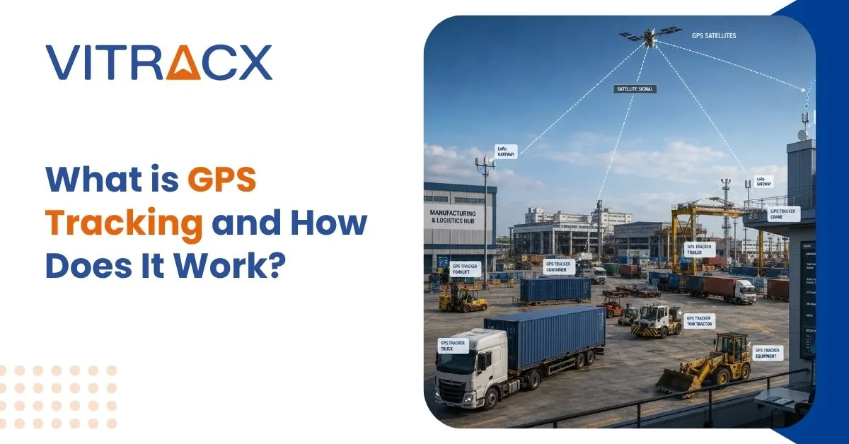
GPS-enabled tracking devices installed on trucks, containers, outdoor equipment, or personnel receive positioning information from satellites and transmit location data through communication networks. The collected data is processed by a centralized software platform that displays live locations, movement history, route information, alerts, and operational insights.
Depending on operational requirements, GPS Tracking is commonly deployed using:
- GPS + LoRa for industrial yards, manufacturing campuses, and confined outdoor environments.
- GPS + Cellular for nationwide transportation, fleet monitoring, and long-distance asset tracking.
This flexible approach enables organizations to choose the most suitable communication technology based on coverage requirements, operational workflows, and deployment costs.
How GPS Tracking Works?
Accurate outdoor visibility begins with the continuous collection and transmission of location data. GPS Tracking combines satellite positioning with wireless communication technologies to provide real-time monitoring of mobile assets throughout their journey.
The process typically involves the following steps:
- GPS satellites determine the location of the tracking device.
- The GPS-enabled tracker collects real-time positioning data.
- Location information is transmitted through either LoRa gateways or cellular networks.
- The tracking platform processes the received data.
- Users access live locations, movement history, alerts, and operational dashboards through a centralized interface.
This automated workflow enables organizations to monitor outdoor operations continuously while improving visibility across industrial yards, logistics facilities, and transportation networks.
GPS + LoRa vs GPS + Cellular
Modern GPS Tracking solutions support different communication technologies to meet varying operational requirements. Selecting the appropriate option depends on the tracking environment, coverage requirements, and infrastructure availability.
GPS + LoRa
GPS + LoRa is designed for industrial campuses, manufacturing plants, and large outdoor yards where assets operate within a defined geographical area. The technology uses LoRa gateways installed across the facility to collect location data while maintaining low power consumption and cost-effective communication.
GPS + Cellular
GPS + Cellular is intended for assets that travel beyond industrial campuses. By using 2G or 4G mobile networks, it provides continuous real-time tracking across regional and nationwide transportation routes without requiring local gateway infrastructure.
| Feature |
GPS + LoRa |
GPS + Cellular |
| Coverage |
Industrial yard or campus |
Nationwide |
| Communication |
LoRa gateways |
Cellular network |
| Infrastructure |
Local gateways required |
No local infrastructure |
| Power Consumption |
Low |
Moderate |
| Best Use Case |
Yard and campus tracking |
Long-distance transportation |
Advantages of GPS Tracking
Organizations implement GPS Tracking to improve outdoor visibility while optimizing vehicle movement, yard operations, and transportation efficiency.
Key advantages include:
- Continuous real-time outdoor visibility
- Live monitoring of trucks, containers, and outdoor assets
- Improved yard management and operational planning
- Better fleet utilization and dispatch coordination
- Flexible deployment with GPS + LoRa or GPS + Cellular
- Real-time alerts and movement insights
- Scalable deployment across multiple industrial locations
Seamless integration with RTLS, ERP, and WMS platforms